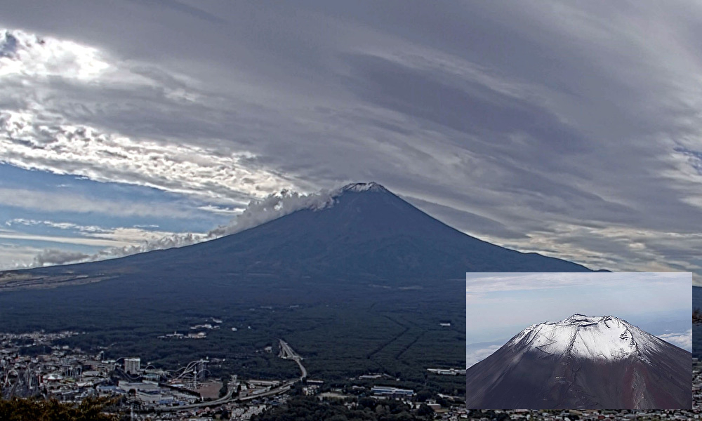
Today, October 5, we received news of the first snowfall on Mount Fuji. It is three days later than average and five days later than last year. The earliest record to date is August 9, 2008, and the latest record is October 26, 2016. Last year (2022), it was observed on September 30. In addition, the first snowfall cap of the season was yesterday, on the 4th, at Mt. Asahidake in the Daisetsuzan Mountains in Hokkaido, and the snowfall cap of Mt. Fuji is second.
By the way, the first snowfall cap on Mount Fuji is observed by the Kofu Local Meteorological Observatory in Yamanashi Prefecture. The condition for the first snowfall cap is that the area around the summit is seen to be white from the Kofu Local Meteorological Observatory after the average daily temperature is the highest day of the year. Even if the first snow is observed earlier in Mishima or Kawaguchiko, that day will not be the first snowfall cap.
Because Kofu is further away from Mount Fuji than Mishima or Kawaguchiko, and there is a high possibility that Mount Fuji will be obscured by clouds in between, the day of the first snowfall cap on Mount Fuji tends to be later than the first snow. There have been many times in the past when the first snow and first snowfall cap on Mount Fuji have differed.
Today, unfortunately, the sky was cloudy, but the sight of Mount Fuji’s snow-capped peak on a clear day is beautiful and clearly tells us the arrival of autumn and the subsequent arrival of winter.
きょう5日、富士山の初冠雪の便りが届きました。平年より3日遅く、昨年より5日遅いそうです。これまでの最も早い記録は8月9日(2008年)、最も遅い記録は10月26日(2016年)で、昨年(2022年)は9月30日に観測されました。なお、今シーズンの初冠雪は、きのう4日の北海道の大雪山系旭岳に続き、富士山の観測は2番目です。ところで、富士山の初冠雪は山梨県の甲府地方気象台が観測していて、「一日の平均気温が、その年の最も高い日」の後に、山頂付近が雪などによって白く見える様子が、麓の甲府地方気象台から見えたことが初冠雪の条件です。もし、三島や河口湖でもっと早く初雪が観測されていても、その日が初冠雪にはなりません。甲府は、三島や河口湖に比べて富士山から遠く、途中の雲によって富士山が見えない可能性が高くなることから、富士山の初冠雪の日が初雪から遅れがちとなります。今までにも富士山の初雪と初冠雪が食い違うことは何度もありました。今日はあいにくの曇り空でしたが、晴れた日の富士山の冠雪の姿は美しく、秋の訪れとその後の冬の到来をはっきりと教えてくれます。